Though the Redwoods to San Francisco

This was day 5 of our trip from Vancouver to Tijuana and our longest drive.  We had to cover some 400 miles, mostly on twisting two lane highways, from our lodge near Gold Beach on the Oregon coast  to San Francisco, a journey which would take more than 7 hours – if we didn’t stop.  This was also to be our day amongst the Giant Redwoods.  Initially, our progress was slow as we were constantly distracted by the views from the coast road.  Most of the time we were able to pull over in a layby, but to view Arch Rock, a massive rock formation along one of the most rugged sections of the Oregon coast, we needed to park up and walk a short trail.

Avenue of the Giants, San Francisco CaliforniaFirst Sight of The Redwoods

Stopping at the mysteriously named Trees of Mystery, located at Klamath, California, we were greeted by a very kitsch 49 foot tall Paul Bunyan, a giant lumberjack of American folklore, and his proportionally large Blue Ox, Babe.   Whilst these are really very large statues (most visitors would not reach Babe’s knee), they did not prepare us for the sheer scale of the Giant Redwoods we saw as we walked the trails.  Whilst they are the world’s largest single trees, they are also both the largest and oldest living things on Earth.  These incredible trees can also be viewed from the top of the forest via a gondola ride, though personally I found their majesty was best appreciated at ground level.

Taking the opportunity for brunch, we visited the Forest Cafe just across the road.  Unsurprisingly, it was forest themed and even more kitsch than the statues.   One of the specialities there is local dish called a Monte Cristo, which we sampled .  This is an XXL French toast sandwich, filled with ham and Swiss cheese, fried, dusted with icing sugar, and served with side of hash browns.   I think of it as the Mr Creosote of Croque-monsieurs.

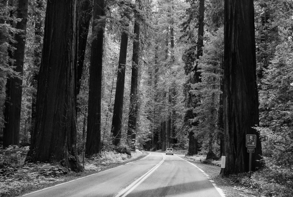
The Avenue of the Giants

The next waypoint on our trip had the advantage of being one we could see without stopping – in theory at least.  This was the Avenue of the Giants, actually State Highway 254, which we entered from the northern end a few miles south of the town of Fortuna, and is pictured here.  The road was once was part of Route 101 until it was bypassed in the 1960s.  It was an incredible driving experience; the highway is lined with magnificent Coast Redwoods and runs parallel to a small and picturesque river.

Coast Redwoods (aka California redwoods) are also astonishingly large.   Curiously, the height these redwoods can attain is related to the availability of fog.  This is because transporting water to such great heights by conventional means is extremely difficult and the upper leaves supplement their water supply by extracting it from fog.

Shrine Tree Chevy Suburban California Redwoods
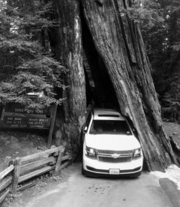
Along the route there is a drive-through Redwood, and it seemed unreasonable not to sample it, especially as, unlike other examples, the opening in the trunk is natural.  As we paid for our $8 ticket (the tree is privately owned), we were told that our Chevy Suburban was the very largest vehicle the Shrine Drive-Thru Tree could accommodate.  Nick drove, I assisted from the passenger side and Ted took photos of the unlikely sight of a huge SUV passing through a tree.  At points there was barely an inch to spare either side, but the paint was still all on the car as we exited.

Shoreline Highway

From the Avenue of the Giants it is just 30 miles or so to California State Route 1, also known as the Pacific Coast Highway (PCH) and the inspiration for our trip.  North to South, it runs 750 miles inland from Leggett, in northern Mendocino, along the coast to Capistrano Beach, which is about 50 miles South of Long Beach.   The stretch we were on passes through Mendocino, Sonoma and Marin Counties and is known officially Shoreline Highway until it reaches the Golden Gate Bridge at Sausalito.

The Shoreline Highway is a beautiful but slow, windy stretch of two-lane blacktop that hugs the coast.  it is not what most people think of as the PCH, which is the section that runs between San Luis Obispo and Monterey, passing through Big Sur, Carmel and Monterey.  I read online that the drive between Leggett and Sausalito could be done in a day, ‘but it would be a tiring one’.  This amused me somewhat as we were already 5 hours into our drive at Leggett.
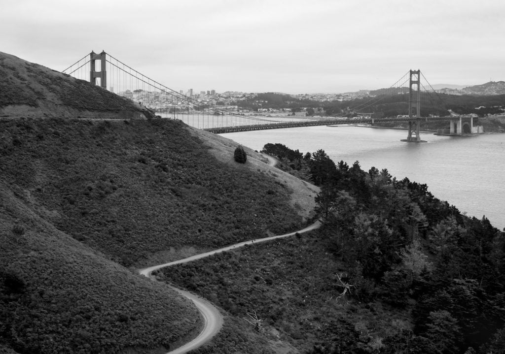
San Francisco Golden Gate BridgeGolden Gate Bridge

After about 3 hours we arrived at Sausalito, cheering in unison as we caught sight of San Francisco’s most famous landmark, the Golden Gate Bridge, resplendent in International Orange.  Ted knew of some places with good views up in the Marin headlands just north of bridge, so we headed under the 101 and up a narrow winding road, which you can see in the photo.

Whilst there are many places to shoot the bridge from this is actually one of the best vantage points in the late afternoon or early evening. Parking, however, at one of the few designated areas, is really difficult.   Once parked up we enjoyed a great view of this truly amazing piece of engineering.  It was constructed in the 1930s and had to overcome wind, fog, deep water, tides and vested interests opposed to its construction to span the Golden Gate strait.  At that time, at 746 high the towers were taller than any building in the city of San Francisco.

J Town, San Francisco

I love Japan, so I was excited to be staying at the Hotel Kabuki in the J Town (aka Japantown and Nihonmachi) part of San Francisco that evening.  This affection for all things Japanese had only become stronger since my 10 day roadtrip across the country the previous year.   There are far fewer Japan Towns than China Towns in the USA, with just 3 versus around 50.    San Francisco’s is both the largest, and oldest.

J Town covers 6-blocks and has many Japanese restaurants and shops mostly along Post Street, between Fillmore and Laguna Street.  Next to our hotel in Post Street is the Peace Plaza, which contains a 5-story pagoda, a gift from the city in Osaka in the 1960s.   We were really pleased with the recently renovated boutique Kabuki, which mixes Japanese and western influences to great effect.    We strolled the few blocks of the area and ate dinner at Izakaya Kou.  Izakaya are Japanese gastro pubs that developed from sake shops which allowed customers to consume the drink on the premises, and typically serve tapas style dishes.  The food was delicious and beautifully presented.

Back at the bar of the Kabuki we reflected that our trip was rapidly coming to an end; we had only our penultimate stop at Pismo Beach before our final night’s stay in San Diego.  The day’s drive had been an epic one of more than 400 twisting miles from our lodge in the Oregon wilderness. At a mere 254 miles the road to Pismo Beach was going to be a breeze in comparison. 

The Magnificent Oregon Coast

US-26 To the Coast

Camp 18 Logging Museum Oregon CoastIt was day four of our epic roadtrip from
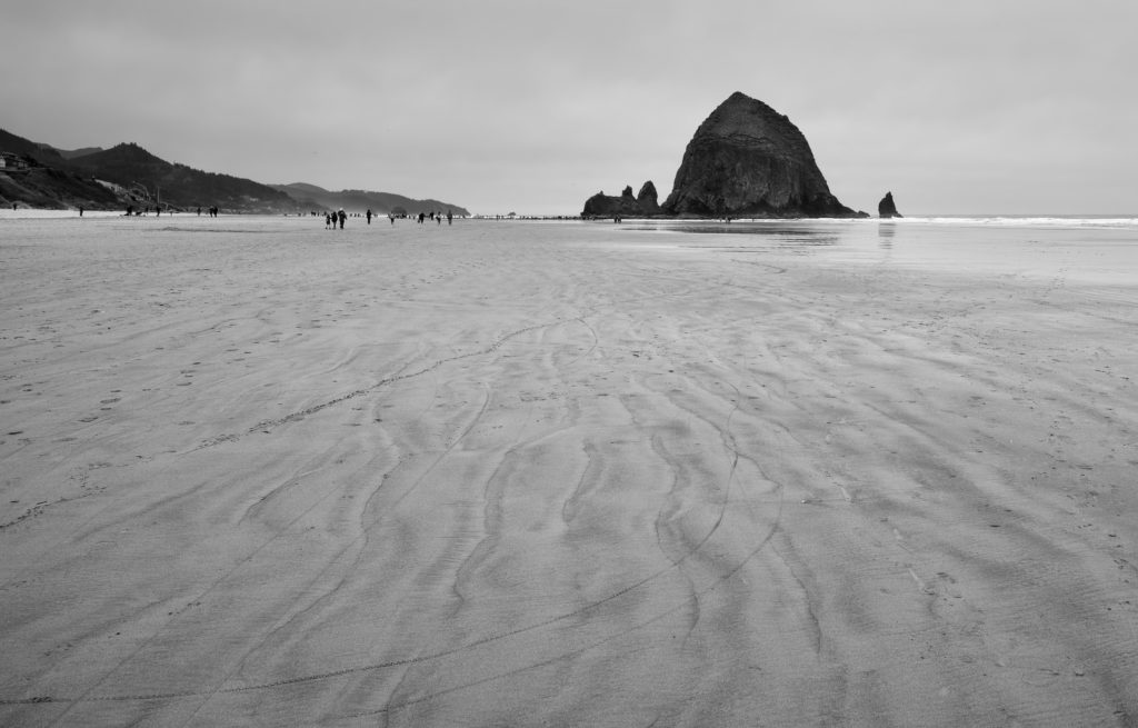
 Vancouver to Tijuana, and time to hit the Oregon coast.  Over the past three days, of the 1,823 miles we would eventually travel between Mexico and Canada we had covered just over 300.  We were also now heading slightly northward so that I could shoot Cannon Beach.  Nick and Ted were impatient to head South, but 60 miles from Portland on US-26 we saw an incredible assortment of rusting and antiquated machinery, and decided to stop.  Barring our short visit to Gas Works Park, Seattle, the trip had not been a photographic success so far.  Heavy cloud in Vancouver, heavy rain in Seattle and heavy drinking in Portland had all got in the way.

We had pulled over at Camp 18 Logging Museum, so called because early logging operations always numbered their camps and the museum is located at mile post 18 on Highway 26, 18 miles from the coast.  There is a great collection of old logging machinery outside in the car park, including steam engines, giant mechanical saws. tractors and the battered old logging truck shown left.

Logging is central to Oregon’s history.  Kick -started by California’s gold-rush and boosted hugely by WWII, the demand for lumber grew and Oregon became a central national and international timber producer with thousands of logging operations.  Today natural resources are a much smaller part of Oregon’s economy, which has shifted to manufacturing, services, and high tech industries.

It was too early for lunch but the restaurant made for interesting viewing – the massive doors are opened with axe handles and the dining room room is held up by an enormous log some 85 foot high and weighing many tons.   There are also several very large wooden statues of the local cryptid Big Foot.  In the gift shop Ted enquired if the shop assistant had ever seen one of the giant wilderness-dwelling bipeds, expecting a dismissive reply.  “You wouldn’t be able to see one if it were stood right next to you”, was her surprising response.  Inspired by this, Nick downloaded an app to track sightings of cryptids in the US and kept us informed of the latest in our vicinity throughout the rest of the trip.   It turns out that cryptid hunting and crypto zoological groups are quite popular in the US.  Big Foot has plenty of legendary company as this map shows.

Cannon Beach Haystack RockCannon Beach

Ever more mindful of the distance we still had to cover, we got back in the Chav Wagon and headed for the coast.  We arrived at Cannon Beach, named after a ship’s cannon that washed ashore in 1846, around noon.  The beach each is famous for the 235 ft high monolith Haystack Rock, which is flanked by the Needles – a pair of tall companion rocks.  It is one of the largest sea stacks on the Pacific Coast and is home to a colony of Puffins.  Canon Beach is probably the best known beach on the Oregon coast, certainly to photographers – but there are several others to explore, which are well described in this article on the best beaches in Oregon.

I carefully set up my tripod from a couple of different angles, watched with a mixture of mirth and frustration by my travelling companions, who were both feeling the chill on the windswept beach.  Focused on my photography I barely noticed the cold, or that the odd hour or two that had passed.

The Oregon Coast Highway

We had coffee at Sleepy Monks near the beach and then joined the Oregon Coast Highway, which would be our companion for the rest of the day.  Its a spectacular piece of two lane blacktop, but subject to landslides, which require a diversion across the coastal range of mountains we had just crossed.  Google Maps showed a distance of 285 miles and a journey time of 6 hours 28 minutes to our next destination, which was Gold Beach.   We paused at Neahkahnie Viewpoint, near Manzanita to admire the view of the apparently endless curve of the beach and numerous other scenic spots along the coast before stopping for lunch at Gracie’s Sea Hag in Depoe Bay, which claims the world’s smallest harbour.  

In addition to the coast views we were much taken by the many fine bridges we crossed, such as the Siuslaw River Bridge at Florence.  They were constructed in the 1920s and 1930s and the product of one man’s vision.  This was Conde B. McCullough, the Oregon state bridge engineer from 1919 to 1935 who combined  Gothic Art Deco and Art Moderne sources to great effect.

The Road To the Lodge

After lunch we made a few more stops for photography, most notably at Humbug Mountain, which we considered to be the perfect habitat for American Hobbits.  By the time we got to Gold Beach it was about 8PM, and we were feeling tired and hungry again.  Gold Beach (originally Ellensburg and renamed after gold was found on a nearby beach), is not the most prepossessing of seaside towns – its known for its jet boat rides on the Rogue River and little else.   The only reason we were stopping there was that we had found an interesting place to stay which conveniently broke our journey.  This was  the Tu Tu’ Tun Lodge, located some miles outside town on the Rogue River.   The road to the lodge was impenetrably dark, somewhat narrow and fearsomely winding.  On our right hand side there appeared to be some precipitous drops into we knew not what.  This combination did not suit vast bulk of our Chevy Suburban particularly well.   To increase our peril, every mile or so a deer would leap out into the road in front of us, seemingly tired of life.  We were relieved to arrive at the lodge safely but found it to be extremely quiet; the main building was locked and deserted.  Our keys were in envelopes outside.  We inspected our rooms which were cabin style found them to be very well appointed with a good sized wood fire.  A wood fire was all very well, but our thoughts at this point were on dinner.

Gold Beach

Oregon Coastal Highway
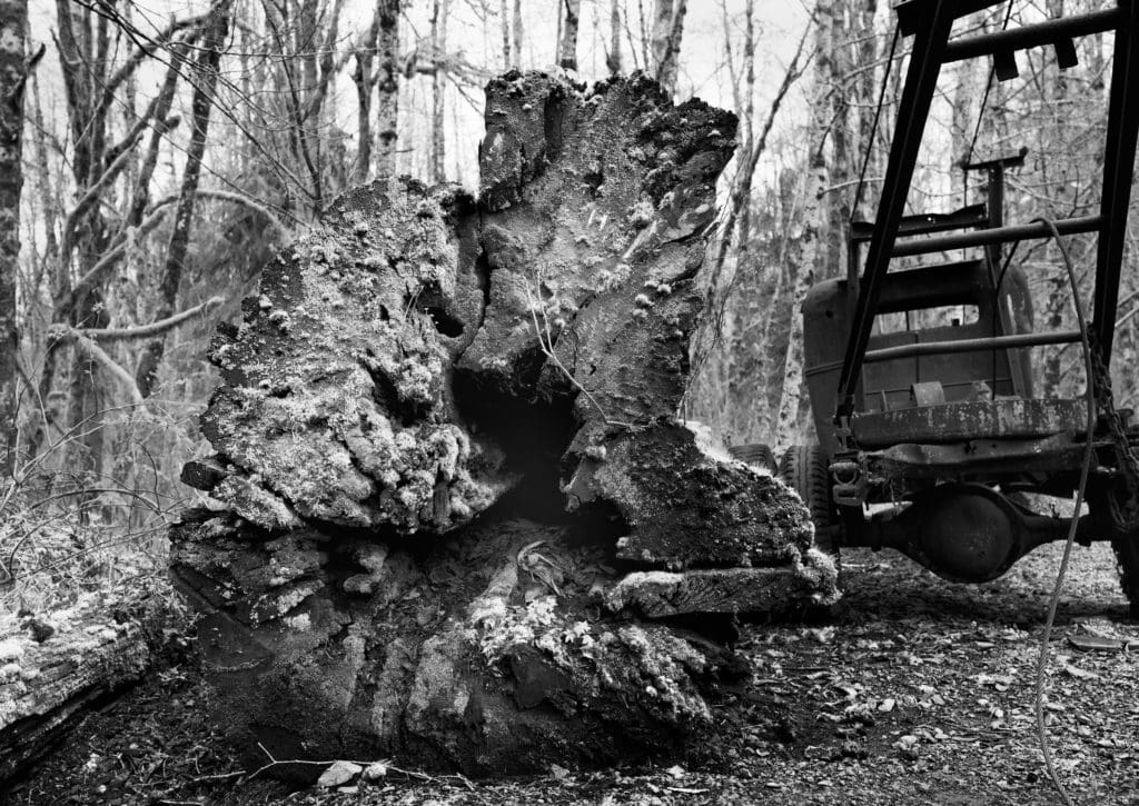
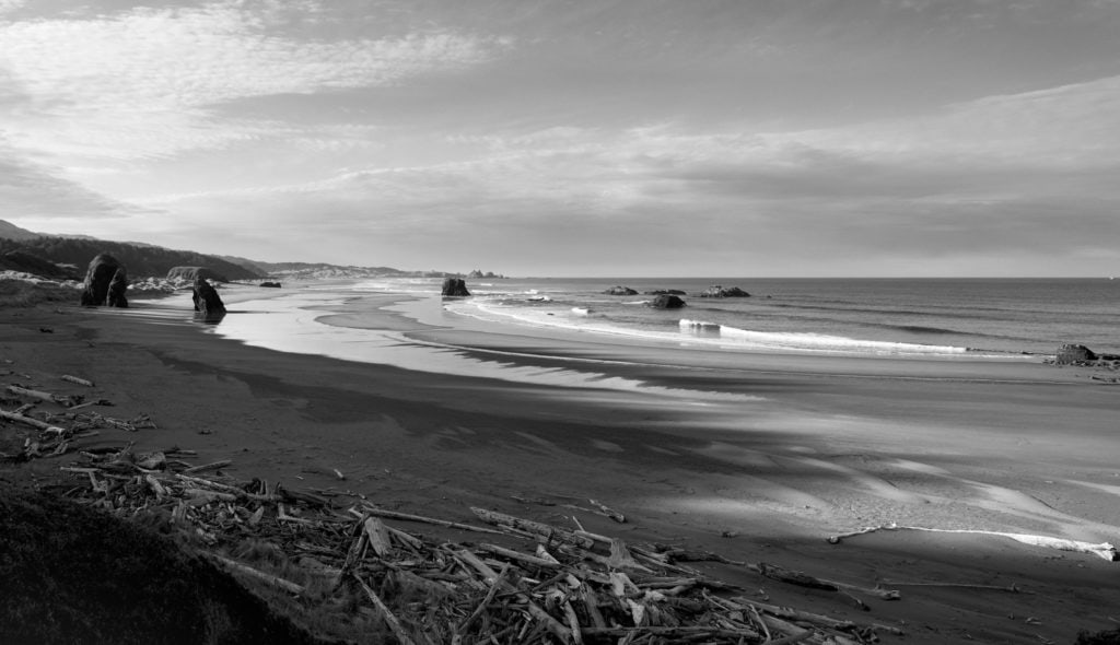
I remembered that there was a small shop some miles back towards Gold Beach, so we set off towards the town.  After a few more close calls with deer we came to the Rogue River Grocery and Tavern in the apparently invisible community of Agness.  As we entered the grocery, lit with an eerie yellow light quite possibly not of this earth, I noticed a large and rather disreputable looking stuffed turkey in one corner.  The head had been removed at some point and glued back on, with a visible white join.   The tavern was out back and in near darkness; a lone drinker sat motionless in the dark.  Reviewing our our choice of ingredients for dinner we found them be be rather limited and settled on a couple of tins of spam, some burger rolls and a copious amount of assorted beer.  With the certainty of eating established, albeit not very well, we quizzed the store keeper about what dining options there might be in Gold Beach.   He shook his head disapprovingly.  “You won’t get anything in town at this time of night.  It’s all shut up now.”   He spoke to us as if we had rolled in at midnight expecting dinner, but actually it was only 8.30 in the evening.

Unsure that this assessment was sound, we headed into town and found the Sea Star to be open.  The Sea Star was a local’s place, but friendly enough, though I was a little wary of the man who paced up and down the bar the entire time we were there.  We some ordered bar snacks, but as they turned out to be rather insubstantial, we finished our drinks and headed back to the lodge.  We lit the fire in my room and Nick cooked spam over the wood fire, which we ate in the burger rolls as we tucked into the beer.  Surprisingly, this turned out to be a better supper than we had expected.

The next morning we awoke to the full glory of being out in the Oregon wilderness.  The Tu Tu’ Tun Lodge really is in a beautiful location.  It’s primary disadvantage for us is that it really is a very long way from Mexico.  This was to be the big mileage day; we had to be cover the 408 miles to San Francisco, which Roadtrippers estimated at 7 hours 15 minutes.  Somehow we also had to find time to stop at least a couple of times to see the giant Redwoods of Northern California.  As soon as we hit the coast road we saw a succession of beautiful beaches.  The beaches of the Oregon coast are long and wild.  The forests come down close to the shoreline, and the shore is decorated with bleached white driftwood.  Offshore, there are large rocks and sea stacks.  In the soft early morning light they were quite breathtaking.   Road tripping on the Oregon coast is often shaded by neighbouring California, but having travelled the length of the US West Coast I can honestly say that it was Oregon that impressed me most.

The Fine City of Portland

Fire Hydrant outside Loyal Legion Portland
Fire Hydrant outside the Loyal Legion

On the third day of our epic roadtrip from Vancouver to Tijuana, we took the I5 Interstate from Seattle to Portland.  It is the main and most direct North-South route in Washington State and the drive takes less than three hours if the traffic is good.  Given a few days to spare, there are mountains, islands and lakes to explore, but there isn’t a lot to see from the interstate.    Arriving at the boutique HiLo Hotel, we dropped our bags and set out to get to know Portland a little better.  Within five minutes of our hotel we stumbled across Jake’s Famous Crawfish, which has been in business since 1892.  Being unfamiliar with both Jake and his renowned Crawfish we stopped there for lunch and found the both the food and beverages to be excellent.

The Loyal Legion

We spent much of the meal debating whether to go on the bike-bar tour of Portland that Ted had booked.  Billed as ‘Beer, Bike and The Portland Way’, it was a 2 hour, 3 stop pub-crawl on a pedal powered bar.  In good weather this would have been quite compelling, but the cold weather, combined with our inherent fear of exertion put us off.  After some debate, which required a few more rounds of drinks to settle, we cancelled the tour.  We had reached out to a friend in Portland, James, before the trip and whilst chez Jake we firmed up our arrangements.  The plan was that we would meet at the Loyal Legion, an establishment whose sole purpose is to celebrate the Oregon Craft Brewing tradition.   Re-orienting our sole purpose to the same, we took a taxi across the Willamette River.

None of us were in particularly good shape when we arrived at the Loyal Legion, as we had been slightly over served at lunch and all felt tired and somewhat listless.  As we stood outside the bar, taking in the bracing air, Ted noticed a man pacing manically back and forth between two posts on the other side of the road.  He remarked that the pacer had the right sort of idea, a comment that refers to his habit of pacing away a hangover.  This was a technique he had used extensively at Nick’s house one particularly painful New Year’s Day, and became known as ‘Ted’s Turkish prison walk’ after a scene from the film Midnight Express.

1,000 Years of Silence

Starting to feel the cold, as none of us had brought adequate cold weather clothing, we ventured inside the Loyal Legion.   Portland has more breweries per capita than any other city in the world, and the Loyal Legion has a fine selection of their beers: 99 in fact.  Looking at the extensive menu I was most taken by a stout called 1,000 Years of Silence from the Fort George Brewery, which I duly ordered.   Nick chastised me for not reading the small print, as the beer is rated at a startling 10.5% ABV.  It was a magnificent brew, but not one you could drink a lot of and remain concious.  James arrived shortly afterwards and we had a great evening with him.  After a good spell in the Loyal Legion we had dinner at the Trifecta Tavern next door and then headed to James’ cigar bar: McMenamins Greater Trumps, where he gave us each a fine cigar.  We participated in the pub quiz and I helpfully illustrated each of our answers, which later proved to be popular with the quiz markers.

Mexico By Friday

Ted had invested in a large scale map of the West Coast, which we pored over with James during the evening, carefully recording his advice on the map.  Our inattention to one of his carefully inked annotations – about landslides – would cost us a great deal of time later in the trip.

The next morning we loaded the Chav Wagon early and were about to set out when a homeless person set about us.  ‘God has a plan for you!’ she screamed, spitting at us with rage.  Sympathetic to the poor woman’s plight but not particularly keen to hear more about God’s plans for us, we set off.  We were headed for Cannon Beach, a renowned beauty spot on the coast.  Getting there meant taking Highway 26 across a small mountain range – and heading slightly North.  ‘You do realise we have to be in Mexico on Friday?’ Ted remarked pointedly as we headed back the way we had come.  This became a frequently used phrase on the rest of the trip – particularly whenever I was setting up my tripod.